Grid reference NC5224
near to Crask Inn [other Features], Highland, Great Britain
Coverage
We have
62 images
in grid square NC5224
Contribute
Explore gridsquare NC5224
Surrounding area
Maps
 Map © Crown Copyright")
TIP: Click the map for more Large scale mapping
Tip: Click the map to open the coverage map
A sample of 12 photos from 62
for NC5224
- View this square in the Browser >>>
|
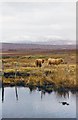
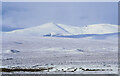
Highland cattle on moorland near the Crask Inn
There are many miles of nothing much between the A836 at Crask and the snow covered summit of Ben Hee in the distance. Great country if you like peat bogs!
|
|
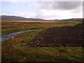
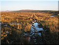
Looking East up Strath a Chraisg
Lairg Estate used to own all this bit of ground leading all the way south back to Lairg Village, but the like a lot of land owners they sold out to the Forestry Commission. Leaving them with only the village of Lairg and surrounding croft... (more)
|
|
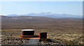
Crask Viewpoint
by Carron K
One of a series of new viewpoints associated with the Flow Country. There's a small parking area and information about the project, and the viewpoint is signed from the A836. The current online mapping shows this area planted with... (more)
|
|
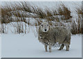
Snowy woolly jumper near Crask |
|
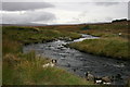
The Tirry flowing near Crask
by Des Colhoun
|
|
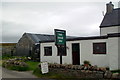
The Crask Inn
by Les Harvey
Remote inn on the A836
|
|
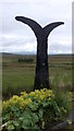
Millennium milepost, Crask Inn
by Richard Webb
These things are either thin on the ground or well hidden in the northern reaches of Route 1.
|
|
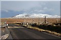
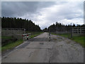
A836, cattle grid and Ben Klibreck
by Alan Reid
|
|
Strath a' Chraisg
by Hill Walker
The beginning of the path to Kinbrace, it looks a bit boggy here, and it doesn't really improve for the first 3 miles!
|
|
Cattle grid near the Crask
by Peter Moore
|
|
Snowed moorland beside the River Tirry
Moorland in Srath a' Chraisg on either side of the River Tirry. Beyond the obvious line of the river the moorland extends towards the distant Ben Hee.
The view is from the A839 south of the Crask Inn.
|
|
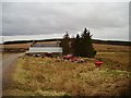
Crask
by Richard Webb
From the pub car park, farm machinery and buildings beside the A836.
|
Explore more images in this square: | View Filtering options | View all 62 images page by page >>> |
|