Grid reference NT2870
near to Craigmillar, Edinburgh, Scotland
Coverage
We have
173 images
in grid square NT2870
Contribute
Explore gridsquare NT2870
Surrounding area
Maps
 Map © Crown Copyright")
TIP: Click the map for more Large scale mapping
Tip: Click the map to open the coverage map
A sample of 12 photos from 173
for NT2870
- View this square in the Browser >>>
|
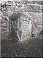
Old Milestone by the A7 south of Edinburgh
Milestone (plates lost) by the A7, in parish of Liberton (City of Edinburgh District), Old Dalkeith Road, The Inch, opposite Walter Scott Avenue, back of footpath, built into red sandstone wall near lamppost OAM34.
Inscription once... (more)
|
|
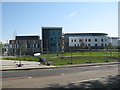
Edinburgh Royal Infirmary
The new building for the Royal Hospital for Sick Children and Department of Clinical Neurosciences at Little France is nearly finished.
|
|
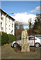
Standing Stone (set of 2 images)
by Anne Burgess
The stone stands in an enclosure at the end of Ravenswood Avenue. See Link
|
|
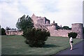
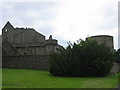
Craigmillar Castle |
|
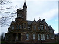
Kingston House, Kingston Avenue
by kim traynor
Originally known as Craigend Park, the house was designed in 1867 by the architects Pilkington & Bell for the Edinburgh tailor, William Christie. For another example of Pilkington's work at a lower end of the social scale, see NT2472 : Fountainbridge tenement
|
|
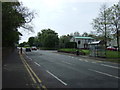
Bus stop and shelter on Old Dalkeith Road (A7)
by JThomas
Looking south east.
|
|
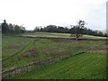
Parkland and fields
by Callum Black
Edinburgh is well off for open, wild spaces within the city limits. These fields surround the castle at Craigmillar.
|

|
Craigmillar Castle Park
by Richard Webb
|
|
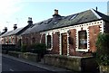
Craigend cottages
by Kay Williams
Unusual (for Edinburgh) row of brick-built nineteenth-century cottages built next to Craigend Park country house.
|

|
Edinburgh - 1975
Edinburgh, Old Dalkeith Road, A7, 'Little France Campsite' back in 1975.
This site is now occupied by the Edinburgh Royal Infirmary NT2870 : New Royal Infirmary from Craigmillar Castle.
|
|
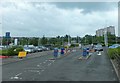
Car park, Little France Crescent
by Barbara Carr
|
|
Craigmillar Castle and Doocot
by Lisa Jarvis
Craigmillar Castle was initially a tower house that still forms the core of the castle. This was constructed around 1400. In the 1440s the curtain wall that surrounds the tower house on three sides and creates the inner courtyard was added.... (more)
|
Explore more images in this square: | View Filtering options | View all 173 images page by page >>> |
|