Grid reference NZ9210
near to Whitby, North Yorkshire, England
Coverage
We have
123 images
in grid square NZ9210
Contribute
Explore gridsquare NZ9210
Surrounding area
Maps
 Map © Crown Copyright")
TIP: Click the map for more Large scale mapping
Tip: Click the map to open the coverage map
A sample of 12 photos from 123
for NZ9210
- View this square in the Browser >>>
|
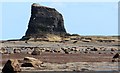
Black Nab
by Bob Embleton
An outlier of shale at the south-eastern end of Saltwick Bay.
|
|
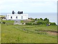
Whitby Fog Signal as was
by Oliver Dixon
The fog signal has now been decommissioned - fortunately for the inhabitants of the house beneath! The Cleveland Way winds its way in front of the Fog Signal Station and behind the Whitby High Light.
|
|
Wild flowers and Meadow
Cleveland way looking North West towards the Whitby High light.
further details of the lighthouse can be found at:
Link
|
|
Saltwick Bay
View towards Black Nab
|
|
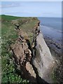
Cliffs near Whitestone Point
by JThomas
|
|
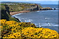
Clifftop gorse
by David Martin
With Saltwick Bay and Saltwick Nab in the distance.
|
|
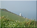
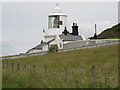
South Whitby Lighthouse
This photograph shows a view of South Whitby Lighthouse taken from the public footpath that runs in front of it. The Cleveland Way long-distance footpath also passes along this route. The picture was taken looking in a south-westerly... (more)
|
|
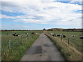
Lane between the pastures
by Pauline E
Cows to the left, bullocks to the right. View towards Ling Hill.
|
|
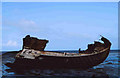
Shipwreck at Black Nab, near Saltwick Bay
In this picture only the Stern section has survived, it is the wreck of the Admiral Von Tromp, which foundered in October 1976 for details of the original ship see:
Link
|
|
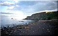
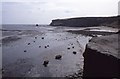
View across Saltwick Bay
The rock on the left is Black Nab.
Date not certain, but probably photographed in 1986. Scanned from a colour transparency.
|
|
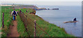
The Cleveland Way approaching Black Nab
"Black Nab" is the small island with the "conning tower". Saltwick Bay is not visible except for Satwick Nab which protrudes into the sea.
|
|
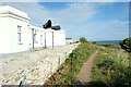
The England Coast Path next to Whitby Foghorn Station
by Jeff Buck
The England Coast Path passing Whitby Foghorn Station.
Whitby Foghorn Station (or Whitby Fog Signal on the OS map), is now a private dwelling, part of which is also used as holiday accommodation known as 'Hornblower Lodge'.... (more)
|
Explore more images in this square: | View Filtering options | View all 123 images page by page >>> |
|