2010
TQ3072 : Odeon Cinema, Streatham High Road
taken 14 years ago, near to Streatham, Lambeth, England
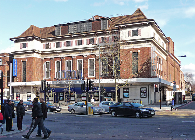
Odeon Cinema, Streatham High Road
Built as the Astoria (an Odeon since 1961), and opening in 1930, this impressive cinema was the work of Edward Stone, a renowned cinema and theatre architect. It has a swept pantile roof, below which are a series of small windows with their original shutters and 1920s 'Roman-style' metalwork. The original interior, lavishly decorated in an Egyptian style, is apparently still there, but concealed behind more recent (and more prosaic) work. Why not indulge us all and uncover it? Streatham is not exactly spoilt for exotica. The opening of the cinema "rivalled anything in the West End, the 16th Hussars played a fanfare of trumpets and a capacity audience of 2,500 watched the opening performance." It is within the Streatham High Road and Streatham Hill Conservation Area.
The course of Streatham High Road has been a major highway between London and Sussex since Roman times. Its current appearance is largely attributable to two major spells of development. The first was during the late C19th following the opening of Streatham Hill station in 1856, and the second was after 1911 when the line to Victoria was electrified. Though much-maligned and undoubtedly blighted by heavy traffic, closer examination reveals that the road is lined with a number of interesting buildings, some of which reflect the period between the wars when Streatham was a fashionable centre of entertainment. Information from Lambeth Council (Link (Archive Link ) ).
The course of Streatham High Road has been a major highway between London and Sussex since Roman times. Its current appearance is largely attributable to two major spells of development. The first was during the late C19th following the opening of Streatham Hill station in 1856, and the second was after 1911 when the line to Victoria was electrified. Though much-maligned and undoubtedly blighted by heavy traffic, closer examination reveals that the road is lined with a number of interesting buildings, some of which reflect the period between the wars when Streatham was a fashionable centre of entertainment. Information from Lambeth Council (Link
 Map © Crown Copyright")
TIP: Click the map for more Large scale mapping
- Grid Square
- TQ3072, 211 images (more nearby 🔍)
- Photographer
- Stephen Richards (more nearby)
- Date Taken
- March 2010 (more nearby)
- Submitted
- Tuesday, 27 April, 2010
- Subject Location
-
OSGB36:
 TQ 302 720 [100m precision]
WGS84: 51:25.9388N 0:7.6786W - Camera Location
-
OSGB36: TQ 301 720
- View Direction
- East-northeast (about 67 degrees)