2007
TQ2590 : Finchley: King Edward Hall, N3
taken 17 years ago, near to Finchley, Barnet, England
Finchley: King Edward Hall, N3
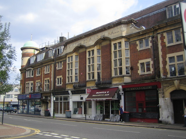
This is the A504 Hendon Lane frontage of King Edward Hall. The tower at the end is shown in Martin's TQ2590 : King Edward Hall. Prior to the construction of the building this was the site of Clement's Nursery.
King Edward Hall was originally built as a private banqueting hall and completed in 1912 to the designs of Turner and Higgins of Finchley. It was used as a temporary hospital during the First World War. It is a Grade II Listed Building and the English Heritage Listed Buildings website describes the exterior thus:-
"Hall and shops. Built in 1911-12 with some later C20 alterations to shopfronts and interior. Built of brick with stone dressings and tiled roofs. Symmetrical corner building with hall to upper floors and shopping parade at ground floor level and corner clock tower. Three storeys and attics: 11 windows to Regent's Park Road elevation, 13 to Hendon Lane elevation (this one). Casement windows with leaded lights with some mullioned and transomed windows. Corner has four storey circular tower with clock face and copper dome with flagstaff. Both sides have a central section of tall stone parapet ramped up with lettering "KING EDWARD HALL" above three tall splayed bay windows rising through first and second floors, linked by elaborate cast iron balustrading. Ground floors have two elaborate doorcases to ground floors on each elevation, those nearest to corner with flat hood on brackets and those furthest away from corner having doorcases with eared architraves, keystones and swag decoration. Ground floor shopfronts have original fascias, pilasters and brackets and some shopfronts are original."
 Map © Crown Copyright")
TIP: Click the map for more Large scale mapping
- Grid Square
- TQ2590, 423 images (more nearby 🔍)
- Photographer
- Nigel Cox (more nearby)
- Date Taken
- Thursday, 9 August, 2007 (more nearby)
- Submitted
- Saturday, 11 August, 2007
- Subject Location
-
OSGB36:
 TQ 250 905 [100m precision]
WGS84: 51:35.9688N 0:11.7976W - Camera Location
-
OSGB36: TQ 250 905
- View Direction
- EAST (about 90 degrees)