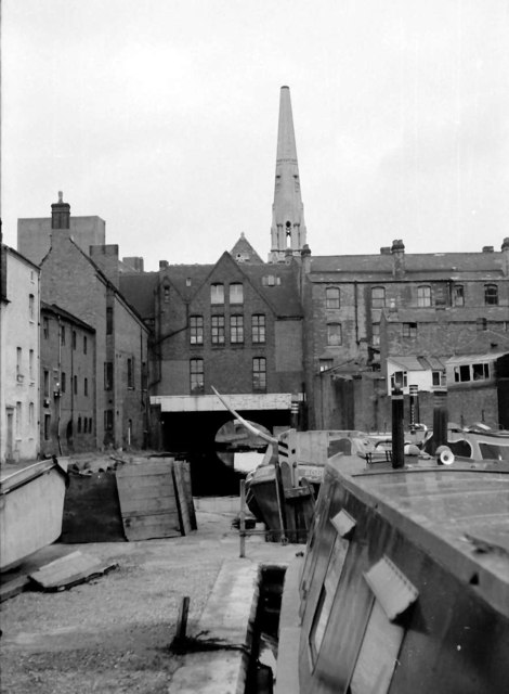
SP0686 : Gas Street Basin - looking towards the tunnel (1968)
taken 56 years ago, near to Birmingham, England
For the equivalent 2008 view see SP0686 : Gas Street Basin, Birmingham - the changes are remarkable.
For a view from the tunnel mouth see SP0686 : Gas Street Basin - the view from Broad Street Tunnel (1968).
Stepping through the door of the high wall on Gas Street took one into a private & totally different world, completely cut off from the hustle & bustle of Broad Street.
In 1968 it was still the world (just) of working narrow boats & there was no indication what so ever of the transformation that was to come to Gas Street Basin. The Birmingham & Midland Carrying Company had been formed by enthusiasts in 1965 & a few of its boats could be found in the basin although in truth I think there was little trade for them by then.
Gas Street marked the point at which the Worcester & Birmingham Canal joined the Birmingham Canal Navigation & each company had its own basin separated by the Worcester Bar. Initially there was no connection between the 2 canals - the BCN refused it because of the fear of losing water to the W&B and any transhipment between boats had to be made manually. In 1815 an Act of Parliament allowed a connection to be made but with a stop lock to minimise water loss. This lock has long since been removed.
 Map © Crown Copyright")
- Grid Square
- SP0686, 3446 images (more nearby 🔍)
- Photographer
- Martin Tester (more nearby)
- Date Taken
- June 1968 (more nearby)
- Submitted
- Thursday, 22 February, 2018
- Subject Location
-
OSGB36:
 SP 0614 8663 [10m precision]
WGS84: 52:28.6539N 1:54.6617W - Camera Location
-
OSGB36: SP 0623 8657
- View Direction
- Northwest (about 315 degrees)